
Want to find out if a COVID case has been tracked anywhere near your home, work or night out? At long last, there’s a decent app for that.
The CRISPER app, launched last week, was developed in a joint venture between the Australian National University and the University of Queensland. It’s an easy-to-use alternative to the endless lists of exposure sites that state and federal departments have been publishing during outbreaks.
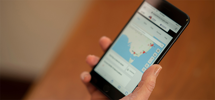
The COVID-19 Real-time Information System for Preparedness and Epidemic Response (CRISPER) project pulls together COVID-19 alerts and exposure locations from across the country, then maps them so anyone can use their smartphone to view hotspots as they move through the community.
Read more: Negative cases transmitting COVID
The information can also be accessed on a desktop, encouraging people to plan outings based on CRISPER information before they leave the house.
And users can enable a function that will alert them to things like new cases or exposure locations in certain areas.
The federal government’s COVIDSafe app was developed to do exactly that – alert users to COVID contact, but it turned out to be a flop because most Australians chose not to upload it. Instead, the public and state governments have turned to QR code check-ins to map our movements and help contact tracers in their work.
Victoria’s health minister, Martin Foley, was blunt when asked if the COVIDSafe app had played any role in his government’s response to the most recent COVID-19 outbreak. His reply was; “No, not to my knowledge, and I’m sure in such a rare event it would have been brought to my attention.”
Read more: Massive fail still costing you millions
CRISPER’s mapping tracks cases, deaths, testing and contact tracing alert locations, so the public is armed with the latest information to make informed decisions about where they can go without minimum risk of catching COVID. But the tools are also built for health authorities.
“The app provides a one-stop shop to review COVID-19 exposure sites and the time of exposure as identified by health departments,” ANU epidemiologist Dr Meru Sheel told the Canberra Weekly.
“Having a one-stop shop can help speed up the process of contact tracing for epidemiologists and build outbreak mud maps to help understand transmission patterns,” Dr Sheel said.
And there are fears that COVIDSafe does not have the capacity to pick up close contacts as the more infectious Delta variant takes hold. Data currently gives state and territory public health officials access to contact information from users who have been within 1.5m of each other for a period of 15 minutes or more. But CCTV has shown the most fleeting of contact can result in infection.
“You just have to walk past someone,” Professor Mary-Louise McLaws told the ABC. The UNSW epidemiologist is an adviser to the World Health Organization and believes COVIDSafe is “very useless” against the Delta variant.
Read more: QR check-ins necessary to contain Delta variant
Forewarned is forearmed and ANU Professor Colleen Lau, who led the CRISPER project, said the technology provided accurate and “spatially explicit” real-time coronavirus updates, The New Daily reported.
“It is nice and visual, and on a map, compared to just getting a list of locations, so it is much easier for people,” Prof. Lau told AAP.
“You can zoom in to where you live or work and see if there are any [exposure site] locations near you.”
Prof. Lau said the app updates around every hour and was more user friendly than trying to keep tabs on the COVID-19 alerts for each suburb, state and territory every day.
She added that CRISPER’s projects could be improved with better access to real time, official health data.
“Each state and territory’s website is structured differently and it can be difficult to find information quickly, so the CRISPER tools help by automatically updating information from health departments across the nation and making them more accessible,” she said.
“Our biggest challenge has been access to live official national data in a ready-to-use format. We could make our tools even more useful if we had better access to data.”
CRISPER has funded a number of other COVID-19 tools including a national summary dashboard, interactive mapping tool for NSW and an automatic alert system.
Go to the CRISPER dashboard and click on the map to see what COVID activity has been happening in your area
Have you downloaded COVIDSafe or CRISPER? Do you think these apps help in the fight against COVID? Have your say in the comments section below.
If you enjoy our content, don’t keep it to yourself. Share our free eNews with your friends and encourage them to sign up.